- April 22, 2024

-
-
Loading
Loading
Four named tropical storms have come and gone in the eight weeks since the start of the hurricane season on June 1 – more than usual for this time of the hurricane season. And if history’s any example, the season should accelerate in August, say forecasters.
The National Oceanic and Atmospheric Administration (NOAA) predicted in May that 13 to 20 named storms would form by the end of the six-month-long hurricane season in November. Seven to 11 of those were expected to become hurricanes (winds of 74 mph or higher) including three to six major hurricanes (Category 3, 4, or 5; winds of 111 mph or higher).
That predicted range is well above the seasonal average but doesn’t come as a surprise to hurricane forecasters. The past three years have all been tied for having the third most named storms on record at 19, and the numbers are likely to stay high for years to come.
“People start to think the forecast is going to be wrong because we haven’t had many storms yet,” meteorologist Scott Spratt of the National Weather Service in Melbourne said. “On a typical year, the third storm doesn’t form until around August 13, so we’re actually about a month ahead of what we would normally be.”
According to Spratt, Earth is in the warm phase of the Atlantic Multidecadal Oscillation, or AMO. This is a natural phenomenon that causes the Atlantic Ocean’s water temperature to rise, which in turn creates a conducive environment for tropical storms to form.
The warm phase started in 1995 and will not end for at least another decade, as the phases of the AMO usually last 30 to 40 years. This, along with the absence of a climate change known as El Niño, led national experts to believe that this will be an active hurricane season.
“El Niño effectively alters the jet stream in the high altitudes of the atmosphere,” Spratt said. “This causes a higher level of wind shear which is disruptive to the circulation of hurricanes.”
While as many as 20 storms are expected to form by the end of the hurricane season, it’s very difficult to tell where these storms will go. Dennis Feltgen, the public affairs officer for NOAA, says that while it’s possible to predict a number of tropical storms that will form, there is no way of telling how many or where they make landfall until about 5 days in advance.
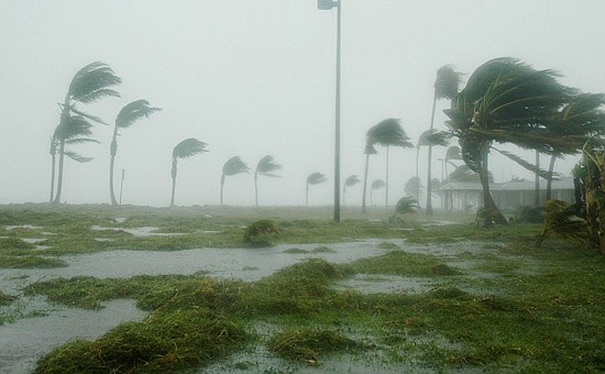
If a hurricane reaches Central Florida this year, residents will need to be most concerned about flooding, strong winds and tornadoes.
The persistent rain characteristic of many hurricanes is enough to cause flooding well inland of the coastline. So Spratt, who also specializes in warning coordination, suggests that if you’re in a geographically low spot you will want to relocate a few days before a storm approaches.
He also wants Central Floridians to heed a special warning.
“Don’t try to correlate the strength of the storm to how bad you think damage will be,” he said. “Even tropical depressions can be very dangerous.”
In fact, most hurricanes weaken significantly by the time they reach metropolitan Orlando. In 2004, hurricane Charlie fell from a Category 4 to a Category 1 by the time it reached Orlando yet still caused a considerable amount of damage.
This was partly due to the tornadoes produced by the hurricane. It’s notable that residents of Central Florida need to be more concerned about a storm when it approaches from the west or southwest, as Charlie did, because it puts the area at a greater risk for experiencing tornadoes.
So, Spratt said, Floridians should be prepared this year. He believes the worst is yet to come, despite the atmosphere being behind compared to national predictions.
“In a typical year, most storms happen in late August and so on,” he said. “It’s very quiet right now, but don’t take that as a false sense of security.”