- April 24, 2024

-
-
Loading
Loading
There are a number of communities in West Orange County that once had promising futures but, for some reason, failed to grow into full cities and towns. Many were wiped out in the 1894-95 freeze. Remnants of their past are still present along the West Orange Trail, in school names, on street signs and on neighborhood entrances.
Clarcona, just north of Ocoee, and Fuller’s Crossing, north of Winter Garden, likely started as nothing more than rail stops.
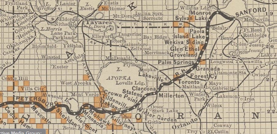
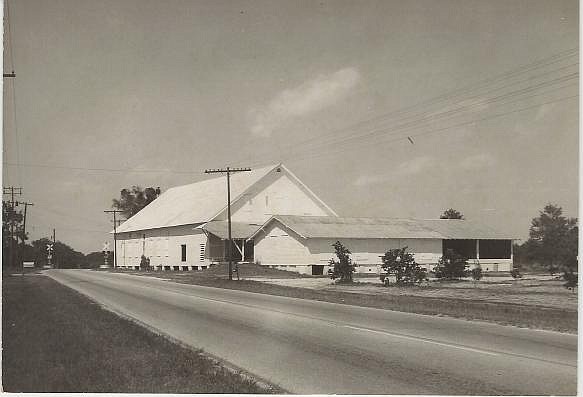
CLARCONA
Downtown Clarcona is basically the crossroads of Apopka-Vineland and Clarcona-Ocoee roads. The best description of Clarcona’s borders is the unincorporated areas of lakes, homes, pastures, nurseries, horse farms, citrus groves and woods between Pine Hills, Ocoee, Fairvilla and Apopka, according to one newspaper article.
Its earliest inhabitants were New England residents who were lured by the promise of free land; their farms in New Hampshire, Connecticut and Massachusetts were no longer at peak production, and they sought a better life in the South. The first, Nathaniel Barlow, homesteaded 160 acres. The second settler was W.N. Clark, who came in 1880.
The settlement continued to grow as more New Englanders moved in. Soon, two railroads — the Orange Belt (later called the Atlantic Coast Line) and Florida Midland — crossed through; and a Congregational Church, packinghouse, store, school, three-story hotel, turpentine still and sawmill were built.
Clark’s sawmill was a major employer in the area, and it is believed the community’s original name was Clark’s Corner — but it has evolved over the years.
Another popular thought is Clark’s Corner was shortened to Clarcona because there was another post office near DeLand by the same name. Clarcona got its own post office in 1887.
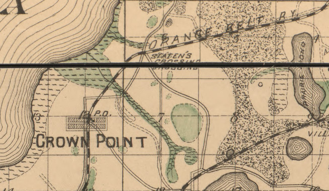
Clarcona was located at the junction of two railroad lines. Once trains left the Clarcona station, they either stopped at Millerton/Villa Nuova, Staten’s Crossing, Crown Point, Winter Garden, Tildenville and Oakland before rolling into Lake County, or they continued south through Ocoee and Gotha.
At one time, several lakes — now dried up — dotted the Clarcona area: Long, Alpharetta, Arlie, Trout and Cora Lee.
The Clarcona Improvement Association was established in 1966, initially in an effort to close down a dump on Damon Road opened by Orange County. The charter membership numbered 120. The residents won, and the county moved the dump. In its place is the 40-acre equestrian park, Clarcona Horse Park.
FULLER’S CROSSING
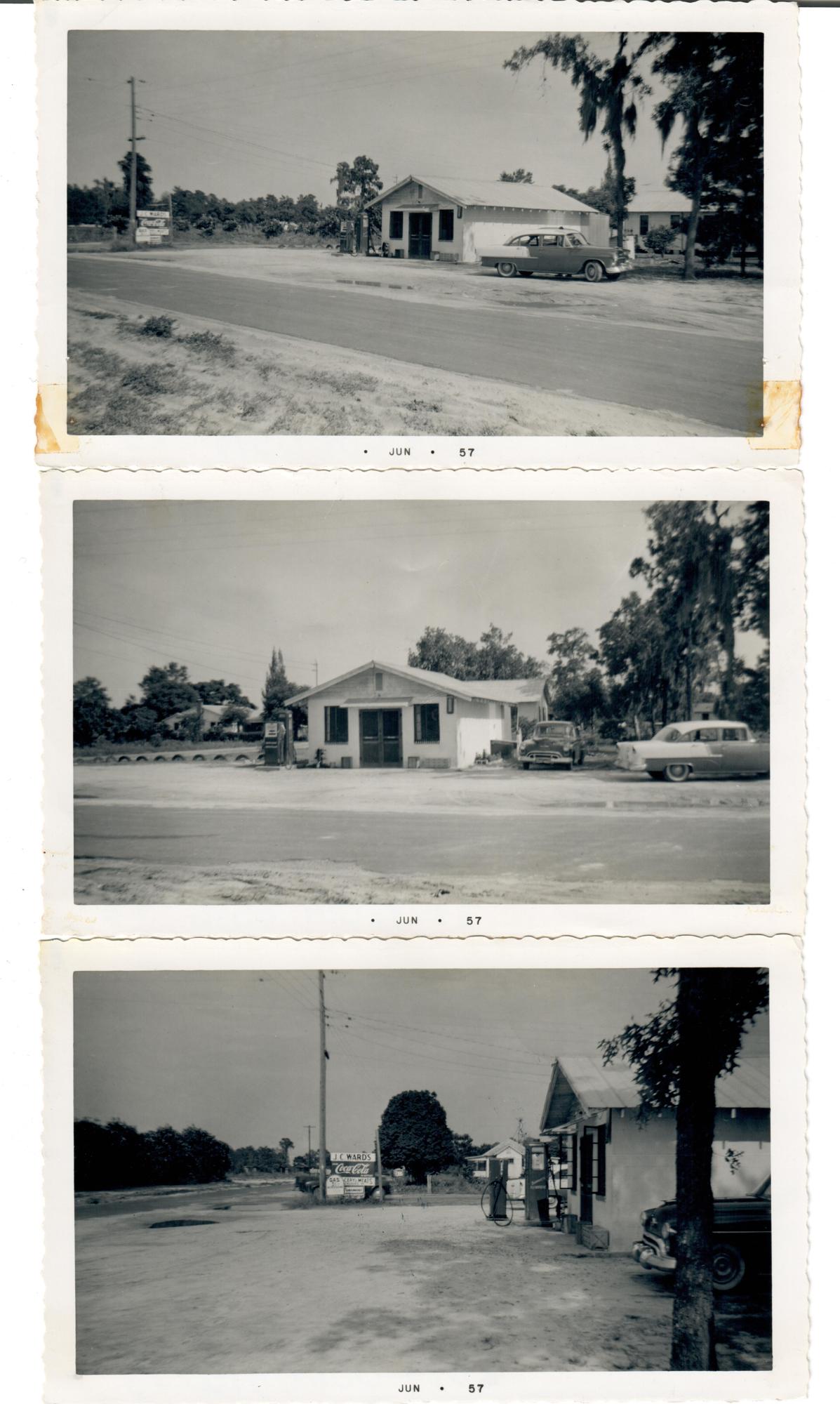
When locals hear the name Fuller, they most likely think of Fullers Cross Road, which unofficially has been called Dead Man’s Curve for decades. But Fuller’s Crossing once was a spot on the map where trains stopped to pick up citrus before continuing down the rail line.
In 1889, Dr. Wylie, Mr. Roland and J.B. Staten of Valdosta, Georgia, bought from the Hudson estate through Judge Speer several hundred acres of choice land, mostly hammock, along the shores of Lake Apopka, which they used in vegetable and citrus growing up to the time of the freeze of 1894-95.
John T. Fuller, formerly of Tennessee, was interested in buying property in Central Florida and found what he was looking for on acreage on the southeast shores of Lake Apopka. It was a place called Staten’s Crossing.
In 1903, Fuller purchased the plot of land for $10,000 from Erma C. Wiley, W.L. Thomas and Fannie R. Thomas, according to a legal document at the Winter Garden Heritage Foundation. The legal description mentions “the centre of a branch, or stream, known as Staten’s Branch” and also uses land markers such as a live oak tree to map the boundaries of the land.
The property, which became Fuller’s Crossing, ran along the edge of Lake Apopka.
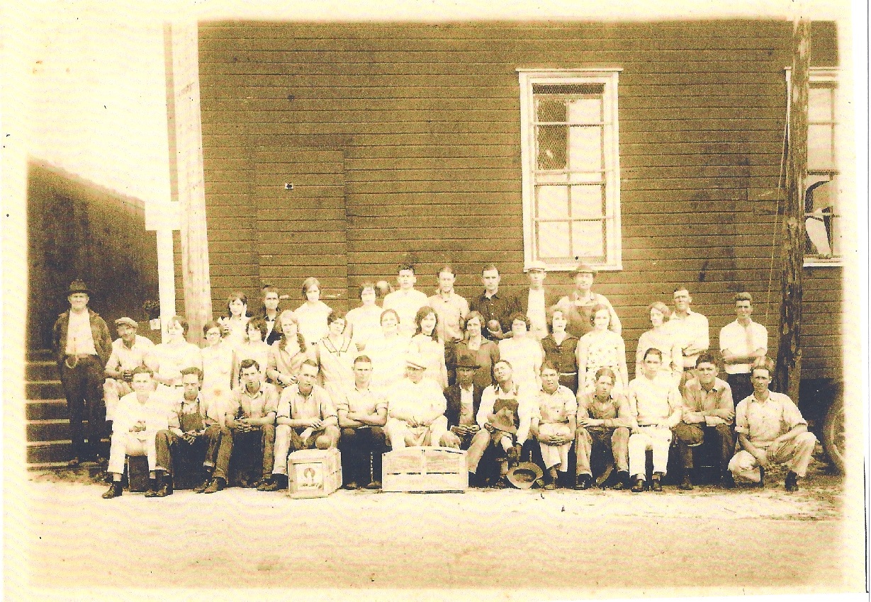
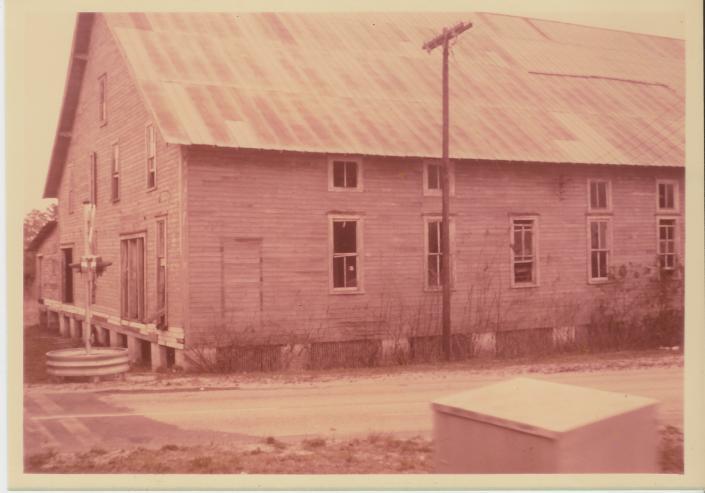
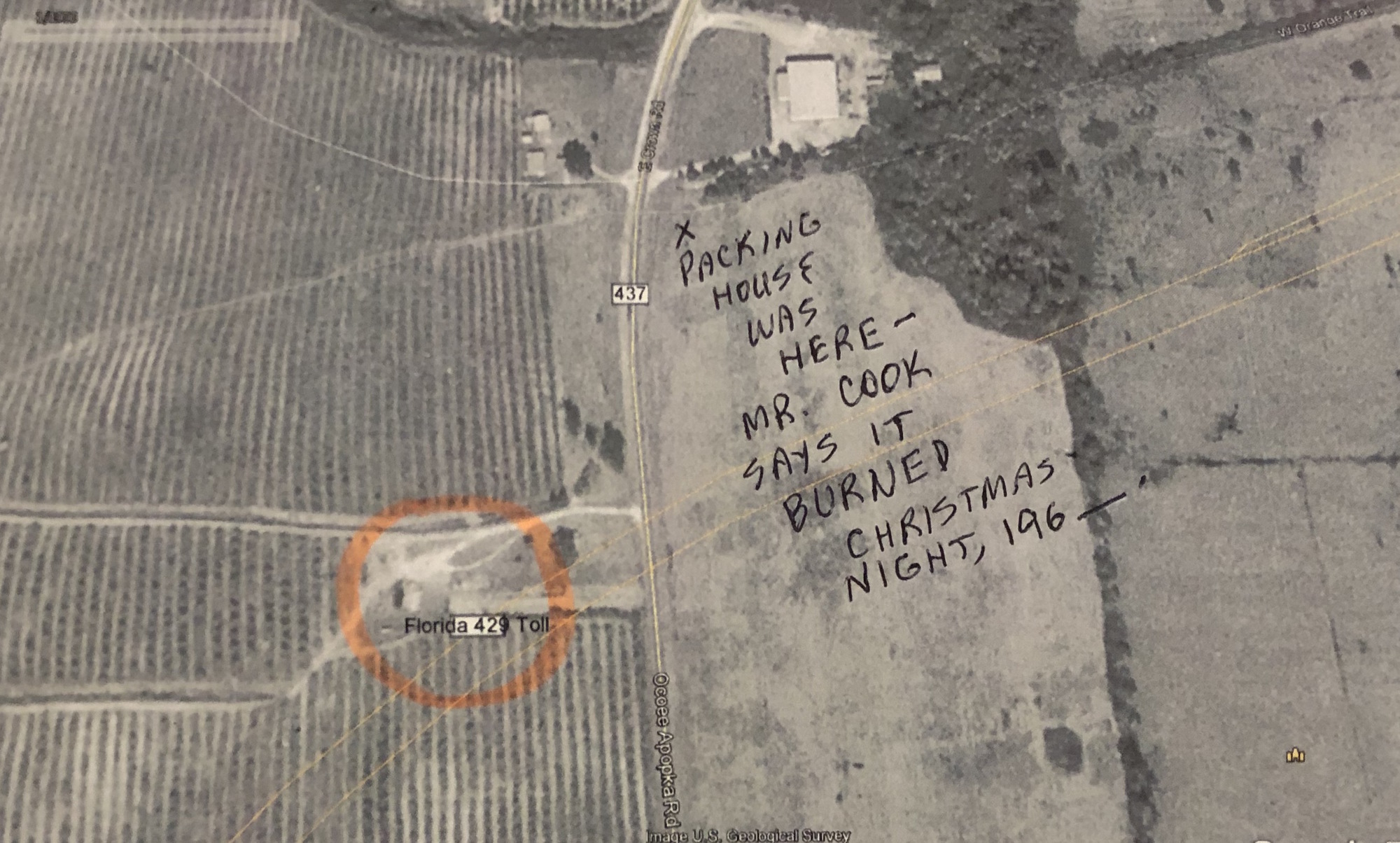
Fuller’s citrus packing house — named John T. Fuller Packinghouse — was located on the railroad stop which, by then, bore the new name Fuller’s Crossing. Fullers Cross Road is the southern boundary of the Fuller property.
The purchase of the land included the right to lease an old packing house — located on the north side of the Orange Belt Railway — in an agreement with Wiley & Co. (or Wilie & Co.), of Titusville; Smythe & Co., orange packers, of Orlando; and the Banyard Brooker Co., of Staten’s (or Statens) Crossing. The document also included an agreement by the sellers to build a new packing house.
Fuller’s packing house was located at the intersection of the West Orange Trail (which was formerly the ACL rail line) and Fullers Cross Road, north of the Crown Point plat.
The structure stood just east of the Ocoee-Apopka Highway and immediately south of the railroad tracks.
According to an article in the Winter Garden Journal in 1933, there were 10 active citrus plants within a three-mile radius of Winter Garden, including the International Fruit Company, at Fuller’s Crossing.
After Fuller’s death, the property was sold to Standard Growers.
Today, the area is heavily forested in pine and scrub.
(All photos courtesy of the Winter Garden Heritage Foundation)