
- July 26, 2024

-
-
Loading
Loading
Winter Park and Maitland residents might have a new conservation trail to look forward to – and it could give some students a new route to get to school.
Winter Park Traffic Manager Butch Margraf discussed a new trail in the works at the Winter Park Transportation Advisory Board meeting on Tuesday. Margraf told board members that he had the chance to meet with Maitland’s city manager and parks director and walk the site of the proposed pathway.
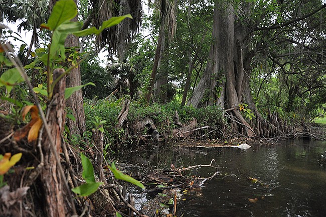
The potential trail would connect Lolissa Lane in Winter Park to Lightning Trail in Maitland to the north, creating a path through the wetlands west of Lake Waumpi. An alternate version of the trail could lead from Lolissa Lane to a point further west along Tuscarora Trail. Both concepts would stretch roughly a quarter of a mile.
“They called it a conservation trail,” Margraf said. “Basically it’s connecting the neighborhoods.”
The trail could provide more connectivity for Winter Park children on the east side of the city to get to Maitland Middle School and Dommerich Elementary School, said Margraf, adding that a feasibility study is expected to be conducted soon.
“We did meet with [Maitland officials] and talked about this,” Margraf said. “We’re waiting to hear back.”
“We’ll see where this goes.”
Board member and Healthy Central Florida Executive Director Jill Hamilton Buss noted that there’s already a similar trail in Maitland used by students to use as an example.
“There’s a trail on the backside of Dommerich that goes into Community Park,” Hamilton Buss said. “It’s a similar idea to that. People use it to get to the park, so it’s really nice.”
Hamilton Buss noted that students who live off Aloma Avenue could use a safer way to head west to schools like Lakemont Elementary School as well.
“All those kids behind the CVS pharmacy would have to go [west] along Aloma the whole way and then up Lakemont,” she said. “They could cut through behind the Outback Steakhouse through that neighborhood, but it’s just very uncomfortable.”
Hamilton Buss suggested a trail that would start along Aloma Avenue near the planned St. Andrews Trail along St. Andrews Boulevard. The path would border the north side of the Mayflower Retirement Community, go through the woods, and connect to the east end of Palmer Avenue to provide a safer route.
“I think that’s really a worthy project,” Board Chairman David Erne said. “It really provides great connectivity for the east side of our city.”
Margraf said the city is currently communicating with the Mayflower about a trail concept.


